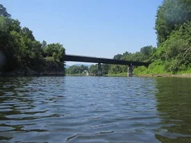
Directions - From Rt. 220 at the Lock Haven Exit. Follow signs to Jay St., cross bridge, turn right and park.
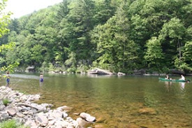
A number of dive operators have used this spot for training dives, so just about any day during the nice weather you have the chance to see divers here. This is a site of its own or you can start here and drift to the boat launch to finish you're dive. Afterwards it's a short walk wearing gear back to your car if your in shape.
There is a picnic pavilion and rest rooms in walking distance. Map
WAVIER IS REQUIRED TO DIVE HERE
KEEP ACCESS TO ROAD CLEAR AND DO NOT DRIVE DOWN. Dive Flag is Required

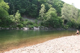
Jay Street Dive Site
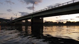
Sunset at Jay Street

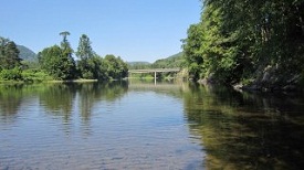
Sunday Night Free Concert Series

Directions - From Rt. 220 at the Lock Haven Exit. Follow signs to Jay St., cross bridge, turn left and go just about a half mile and enter Riverview Park. The park has picnic tables, restrooms and a playground for kids. This is a short fun drift dive that ends at either the Jay Street Bridge site or continue down to the Woodward Township boat launch. You will want to get permission from a lot owner to enter the water. You may also want to leave another vehicle at the end of the dive to get back to the park.
WAVIER IS REQUIRED TO DIVE HERE - Permission needed for entry to water - Dive Flag is Required - Map


Directions - From Rt. 220 at the Lock Haven Exit. Follow signs to Jay St, cross bridge, turn right and park. The entry point is the Jay Street Dive site however on this dive follow the bridge shadow across the river and work your way down to the stage. In the summer time many fish hide in the shadows of the stage. Remember, Sunday Night in the summer is the concert series and this is not a place to be diving then.
There is a picnic pavilion and rest rooms in walking distance. WAVIER IS REQUIRED TO DIVE HERE - Dive Flag is Required .....KEEP ENTRY TO ACCESS ROAD CLEAR AND DO NOT DRIVE DOWN.

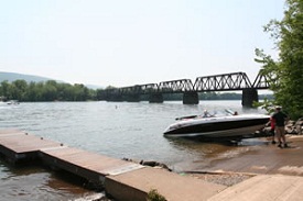
Directions - This spot is located 2 tenths of a mile downstream from Jay Street Bridge. Restrooms, picnic tables, parking area and the Old Canal House make this a nice place to end your drift dives. Just remember this is a working boat ramp so be sure to clear the area as soon as possible at the end of your dive,
WAVIER IS REQUIRED TO DIVE HERE - Dive Flag is Required


Directions - From Rt. 220 at the Lock Haven Exit. Follow signs to Jay Street., cross bridge, turn left and go 1.8 miles, turn left and go 0.1 mile. Log cribs are opposite large white house on hill across river.

A Lock Haven log boom, smaller than but otherwise similar to the Susquehanna Boom at Williamsport, was constructed in 1849. Large cribs of timbers weighted with tons of stone were arranged in the pool behind the Dunnstown Dam, named for a settlement on the shore opposite Lock Haven. The piers, about 150 feet from one another, stretched in a line from the dam to a point 3 miles upriver. Connected by timbers shackled together with iron yokes and rings, the piers anchored an enclosure into which the river current forced floating logs. Workers called boom rats sorted the captured logs, branded like cattle, for delivery to sawmills and other owners. Lock Haven became the lumber center of Clinton County and the site of many businesses related to forest products. (article taken from Wikipedia)
Diving by boat is the best way to dive here. Weekend diving encounters a lot of boat traffic in this narrow part of the river. Weekdays would be the best time to explore this area. When diving from the shore remember to get permission from the land owner for entry to the water - Dive Flag is Required Map

Directions - From Rt.220 at Montoursville. Take 87N for 4.2 miles. Park behind Baptist Church at the far end. Entry is at the bottom of hill, down the dirt road across from the church. Remember there are services Sunday & Wednesdays. Map
YOU SHOULD NOT DRIVE DOWN THE DIRT ROAD. Area neighbors have not been happy about people who do.


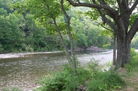
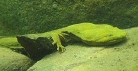
Directions - From Rt. 220 at the Montoursville Rt 87 exit. Take 87N for 5.3 miles. Park in the Pier 87 Restaurant & Bar parking lot if it is still there after the flood. This site could be snorkeled, it's a small area but a lot of fun on scuba. Best to suit up near your vehicle and walk to the waters edge, then walk across the stream. The deepest area is on the downstream side of the big rock where swimmers jump in. Some of the best fun though is to stay as close to the rock as possible and work your way upstream through the current. When you can't get any further push out and ride the current downstream. Just upstream of this site many hellbenders have been sighted and filmed. Map


Directions - From Rt. 220 at the Montoursville Rt 87 exit take 87N for 8.0 miles. Parking is on the left side at the archery range. This is a long narrow dive site that reaches about 20 feet in depth. I think it is much more fun diving at night. Membership information is available at the yellow farmhouse on right side of the road just up from the dive site. Map
Membership is Required

Directions - From Rt. 220 at the Montoursville Rt 87 exit take 87N for 10.1 miles to Little Bear Creek sign on right. Park, cross bridge to private road on left. I have never used this site but it is listed because I know a number of people who have enjoyed diving here in the past. Map

Directions: These directions are a bit tricky because of the way the roads are setup so these directions are coming from Jersey Shore on Rt 220 heading north. Starting from the 220/287 interchange take Rt 220 north for 8.1 miles. Take the 4th St. exit, turn right at the 1st right turn, cross 2 sets of RR tracks. Haywoods is on left; parking lot on right. Weekend diving encounters a lot of boat traffic in this part of the river. Weekdays would be the best time to explore this area. Dive Flag Required Map


Directions: From Rt. 220 in Williamsport. take the Maynard St. exit and cross the bridge to the South Williamsport side of the river. Turn left at light. Turn left at Winthrop . Go two blocks to the gravel lot on left. Dive site is over the hill (dike). Dive Flag Required Map

Directions: From Jersey Shore on Rt 220 south go to the Pine Creek exit. At the end of the exit ramp turn left and go to the crossroads and turn left. Just before you come to the bridge over Pine Creek there is a parking area on the right. Entry to the creek is straight ahead and the bridge is downstream. This is a long swim but not hard going to the bridge. Coming back stay on the left side of the creek to stay out of any current.. Map


Directions: From Rt. 220 at the Pine Creek exit take Rt 44 north and go 7.5 miles. On the left side of the road there is a small parking area near the RR bridge to leave your first car. Going back down Rt 44 south for 1.2 miles there is just enough room along the side of the road to leave your second car for the end of the dive. The area is across from the old Camp Kline High Adventure base for the Boy Scouts. There are concrete steps here to exit the water. This is a fun drift dive. The higher the water the faster the trip. It is also a great place to snorkel. For many years we would get together as the ice was leaving in early spring with just wetsuits & snorkeling gear and fly down the creek. A lot of big fish have been seen in this area. Map


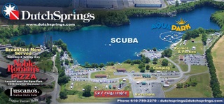
This quarry continued supplying limestone until the 1970s when National Portland Cement went out of business. When operations ended and the pumps were shut off, the quarry, now as deep as 100 feet in some areas, flooded again, becoming a 50-acre lake. In 1980, the property was purchased and converted into one of the largest fresh-water scuba diving facilities in the country. Dutch Springs is spring fed from an underground aquifer that seeps through the limestone, filtering it to provide 20 to 30-foot visibility, which makes it ideal for scuba diving. Today, Dutch Springs has expanded to include the Aqua Park, Sky Challenge, and NorthStar Adventure, which provides adventure-based teambuilding experiences for corporations and other groups. Their goal is to make Dutch Springs a recreational facility with adventure fun for the entire family. Map Web Site


Blue Hole Quarry is a privately owned rock quarry. It is 35 feet at its deepest part. The owner, the Burkettes, permit scuba classes to dive there. Reservations must be made in advance. There is no public swimming allowed. The quarry is approximately 1,051 fee long, the south end is approximately 220 feet wide, and the north end is approximately 130 feet wide. The east wall is OFF LIMITS to divers. The wall above the quarry has loose rocks and they can often be heard falling into the quarry.
The quarry is 27 feet deep. Water temperature is usually 50 degrees with a visibility of 10-20 feet. Average water temp in summer is mid 60's with visibility of 5-10 feet.
Blue Hole is Private property, you must obtain permission and fill out releases to dive there. Contact http://laureldivers.com/ Map

What is DiveCaching?
DiveCaching is all about adventure and fun. It’s an underwater game for certified divers or snorkelers that can be organized by your local retailer or by a group of divers and is ideal for staying involved in both local diving and for dive travel.
If you’ve been out of the water for a while, this is also a great and fun reason to take a refresher scuba course and get back into diving!
DiveCaching is essentially an underwater “treasure” hunt that combines your certified scuba diving skills or snorkeling skills with some high tech equipment and simple underwater search techniques, while looking for a hidden “cache” of goodies. The premise is simple; divers hide a “treasure” or cache underwater, they post the location of the hidden cache online, and other divers search for it. When the cache is found, the finder logs their visit to the cache online, and puts the cache back where they found it. Sometimes the finders enhance the cache by adding something to it.. Other times the finders simply put the cache back in the hiding place for the next dive cacher to locate. After returning to the surface, the visit to the cache is logged online.
There are many rewards for DiveCaching and everyone has their own favorite reason for participating. Some will thrive on the fun and adventure of discovery. Others enjoy exploring a new dive site or returning to one that they have not visited in a while. Still others enjoy practicing their diving skills or using new skills in navigation or search and recovery, or just simply being with friends and family. Some, especially the younger DiveCachers, will love the treasure!
The cache itself is usually composed of a container holding a log book or log sheet, something with which to write, and various items that might be of interest to the dive cacher, such as collectible coins, lapel pins, key chains, beads, money, stones, or other treasures. These items, known as SWAG (Stuff We All Get) can include handmade items, stuff from the dollar store and anything else the DiveCacher can imagine. Items don’t need to be expensive but should be a reflection of the cacher’s personality.

The cache container is hidden underwater and out of sight of non-caching divers or swimmers. The surface coordinates of the item are recorded using a Global Positioning System (GPS) and are posted online so that other divers can find the cache. DiveCaching is a form of “Geocaching,” a decade-old land-based activity with more than 5 million participants worldwide who are looking for (mostly land-based) caches hidden by others and posted on the internet. So let the fun begin and look at a new way to enjoy your dives.
Find a Cache hidden by Sunken Treasure Scuba Center, then stop by the store and get the geocache sticker for your log book. So where is one around here? Jay Street Cache - GC Code - GC2YV9V